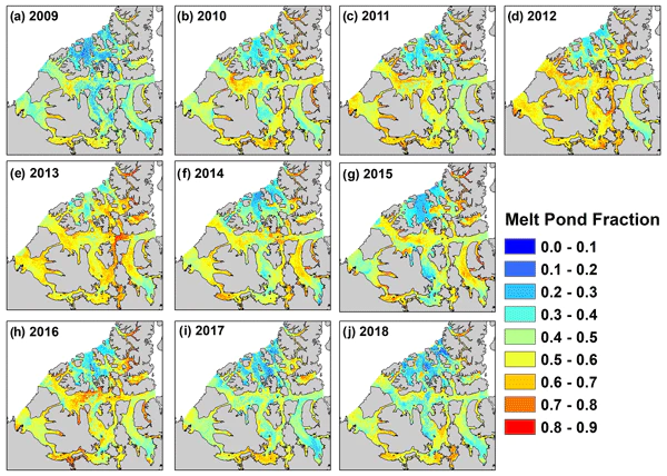
 Figure 3
Abstract
Melt ponds form on the surface of Arctic sea ice during spring, influencing how much solar radiation is absorbed into the sea ice-ocean system, which in turn impacts the ablation of sea ice during the melt season. Accordingly, melt pond fraction $(f_p)$ has been shown to be a useful predictor of sea ice area during the summer months. Sea ice dynamic and thermodynamic processes operating within the narrow channels and inlets of the Canadian Arctic Archipelago (CAA) during the summer months are difficult for model simulations to accurately resolve. Additional information on $f_p$ variability in advance of the melt season within the CAA could help constrain model simulations and/or provide useful information in advance of the shipping season. Here, we use RADARSAT-2 imagery to predict and analyze peak spring $f_p$ and evaluate its utility to provide predictive information with respect to sea ice area during the melt season within the CAA from 2009–2018. The temporal variability of RADARSAT-2 $f_p$ over the 10-year record was found to be strongly linked to the variability of mean April multi-year ice area and the spatial distribution of RADARSAT-2 $f_p$ was found to be in excellent agreement with the sea ice stage of development prior to the melt season. RADARSAT-2 $f_p$ values were in good agreement with the peak $f_p$ observed from in situ observations but were found to be ∼0.05 larger compared to peak MODIS $f_p$ observations. Statistically significant detrended correlations between RADARSAT-2 $f_p$ and summer sea ice area were found for several regions within the CAA. Our results show that RADARSAT-2 $f_p$ can be used to provide predictive information about summer sea ice area for a key shipping region of the Northwest Passage.